Throughout history, countries have drawn boundaries and defined territories for various reasons, such as security, resources, and cultural differences.
However, not all borders are equal, and some are ridiculous. Here, I look at some of history's most absurd country borders.
Baarle-Hertog/Baarle-Nassau: The Belgian-Dutch Enclaves
The border between Belgium and the Netherlands is marked by a strange jigsaw puzzle of enclaves and exclaves, where the two countries overlap in a bizarre checkerboard pattern. The town of Baarle-Hertog in Belgium has 22 small pieces of land surrounded by the Dutch municipality of Baarle-Nassau. To add to the confusion, some houses are split between the two countries, with the front door in one country and the back door in another.
India and Bangladesh: The World's Largest Enclave
The India-Bangladesh border is home to the world's largest enclave, a piece of land surrounded by another country. The Dahala Khagrabari enclave is an Indian enclave within a Bangladeshi enclave inside India. To make matters even more complicated, there is another Indian enclave, called Balapara Khagrabari, within the Bangladeshi enclave.
Argentina, Brazil, and Paraguay: The Triple Frontier
The Triple Frontier is where Argentina, Brazil, and Paraguay meet, and it is known for being a hub for illicit activities such as drug trafficking and money laundering. The border is marked by the Paraná and Iguazú rivers, making it difficult to police, and it has been a source of tension between the three countries.
Egypt and Sudan: The Hala'ib Triangle
The Hala'ib Triangle is a disputed area on the border between Egypt and Sudan. The triangle is located along the Red Sea coast and is rich in natural resources such as oil and gas. Both countries claim sovereignty over the territory, and tensions have risen in recent years due to the discovery of oil in the area.
Canada and Denmark: Hans Island
Hans Island is a small, uninhabited island in the Arctic that Canada and Denmark claim. The two countries have been in a friendly rivalry over the island for decades, with each country leaving a bottle of their respective liquor at the island's summit for the other to find and replace.
North Korea and South Korea: The Demilitarized Zone
The Demilitarized Zone (DMZ) is a heavily fortified buffer zone that separates North and South Korea. The zone is approximately 4 kilometers wide and 250 kilometers long, and it is one of the most heavily guarded borders in the world. The DMZ was established in 1953 after the Korean War, and it remains a tense and dangerous flashpoint between the two countries.
Pakistan and Afghanistan: The Durand Line
The Durand Line is the border between Pakistan and Afghanistan, which the British drew in 1893 without regard for ethnic or cultural differences. The border has been a source of tension between the two countries, with Afghanistan disputing the line's legitimacy and claiming it divides the Pashtun tribe.
Morocco and Spain: The Spanish Enclaves
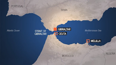
The Spanish enclaves of Ceuta and Melilla are located on the northern coast of Africa and are surrounded by Moroccan territory. The enclaves are remnants of Spain's colonial past and have been disputed between the two countries for decades. The enclaves are also a major entry point for migrants trying to enter Europe.
United States and Canada: The Angle Inlet
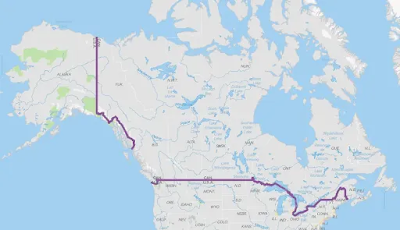
The Angle Inlet is a small piece of land in the northernmost point of Minnesota that is only accessible by crossing into Canada. The area was left as an oddity after the US-Canada border was redrawn in 1826, and it has become a popular tourist destination due to its unique location.
China and India: The McMahon Line
The McMahon Line is the border between China and India, which the British drew in 1914 without the consultation of China or Tibet. The border has been a source of tension between the two countries, with China claiming that the line is invalid and that it should control the Indian state of Arunachal Pradesh.
Conclusion
Borders are essential for defining territories and ensuring national security, but some borders have been drawn in illogical and absurd ways. The examples above demonstrate how borders can be created for political, economic, and historical reasons, leading to bizarre and complicated situations.
Despite the difficulties caused by these borders, they also demonstrate the complexity and diversity of our world.


0 comments:
Post a Comment